Glen Boulder Trail – Davis Pass
U-turn at White Walker territory
I have been to the Kingdom of the North, beyond The Wall, and I lived to tell the tale.
Ummmm for real… this hike. They didn’t name it Mt. Isolation for nothing. It’s in the middle of nowhere (duh). Here’s the hilarious part: I picked it because it’s the second to last on the 4000s list, a wee 4003 feet, and I thought it would be easy.
Hahahahaha. That’s the sound of a White Walker laughing at me.
Okay, serious talk now. The day I chose for this hike was mild, temps in the 30s, with very little wind predicted at the top of Mt. Washington. It was overcast, but no rain or snow was predicted. Still, it wasn’t exactly a bluebird day. It was January… a.k.a. still winter. The sky was gray and dreary, and the shortest route I found to the summit was up Glen Boulder Trail to Davis Path. And by shortest, I mean over 11 miles.
What in the world of Westeros was I thinking?

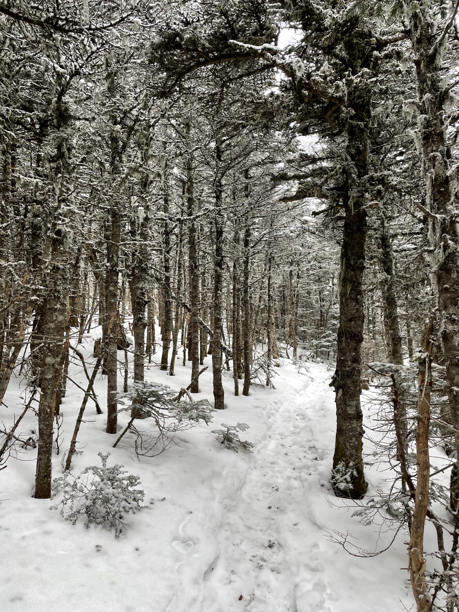
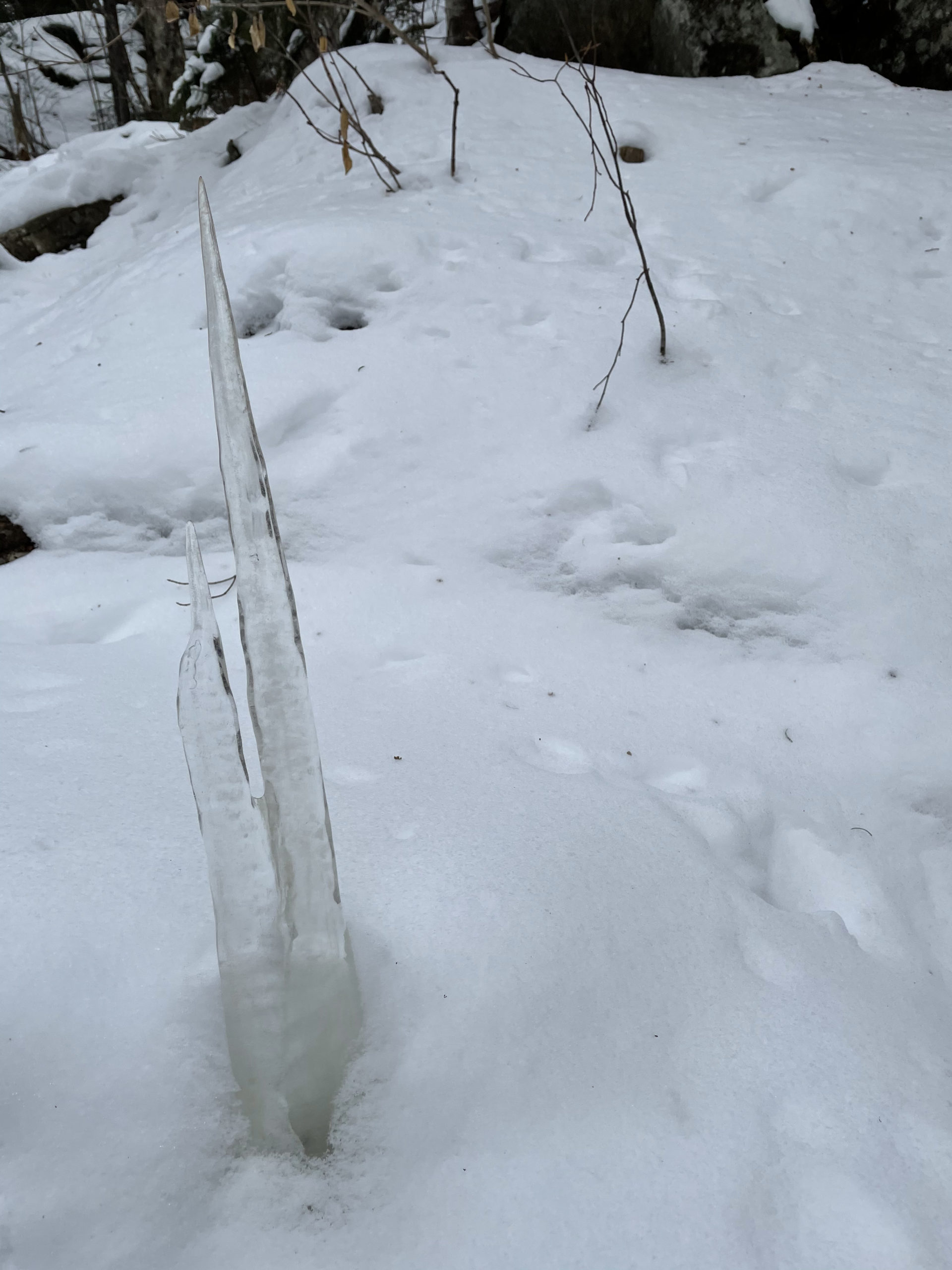
I parked off Rt 16, on a pull-off leading to the seasonal lot for Glen Ellis Falls. The lot itself was gated off and unplowed, so I stopped just outside the gate. Mine was the lone car anywhere nearby (‘lone’ is about to become a theme here). I was definitely not supposed to be there, I learned several months later while researching for a different hike, but oh well. I scooted across Rt 16 and picked up the trail, which ascends easily for about a half mile to the base of a small cliff. Here I passed large faces of rock sheeted over with thick slabs of ice and icicles taller than me. The incline increased significantly and climbed steadily through the woods for a mile and change, until the trees gave way to the alpine zone.
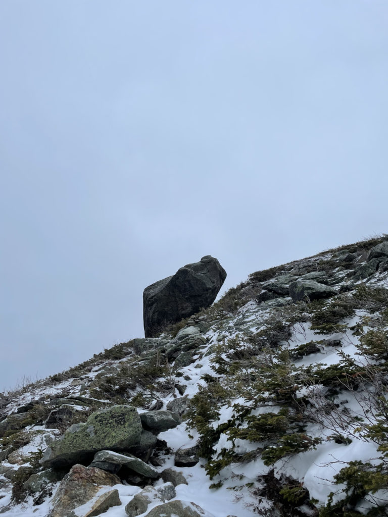
The rocky climb led up to Glen Boulder. It is an enormous rock, called a glacial erratic, perched on the edge of a spur. It seems absolutely impossible that it hasn’t fallen down, given how long it’s balanced here. The Ice Age was, what, 20,000 years ago? And in all the time since then, no minor (or major) tectonic shift of the earth’s plates has sent it on its way? Astonishing.
After the boulder, the trail continued steeply over the open, rocky ridge. The view here is expansive; even limited by the clouds I could see multiple peaks in every direction. The foliage was frosty and any step off the trail was a knee-high sink. I picked up a rabbit trail—the only other footprints in the snow—and followed it into the next stretch of woods (or, since we were now above the treeline, technically ‘high scrub’). The branches were low and heavy with snow, and I had to stoop to pass under them or push them out of the way, which resulted in a lot of snow on my head and in my hood.
Hiker term: Glacial erratic
A rock carried and deposited by a glacier, usually differing in size and type of rock native to the area in which it comes to rest.
When I stepped out of the scrub, the world in front of me was completely foreign. It was absolutely silent. Colorless except for shades of gray and white. Shrouded in fog. The trail was gone, except for the rabbit prints and cairns that were often hard to find. I realized: Not only had I not seen another human, I hadn’t seen any living thing. No birds, no squirrels, no rabbit that made the path. It was eerily peaceful and beautiful… and also unsettling.
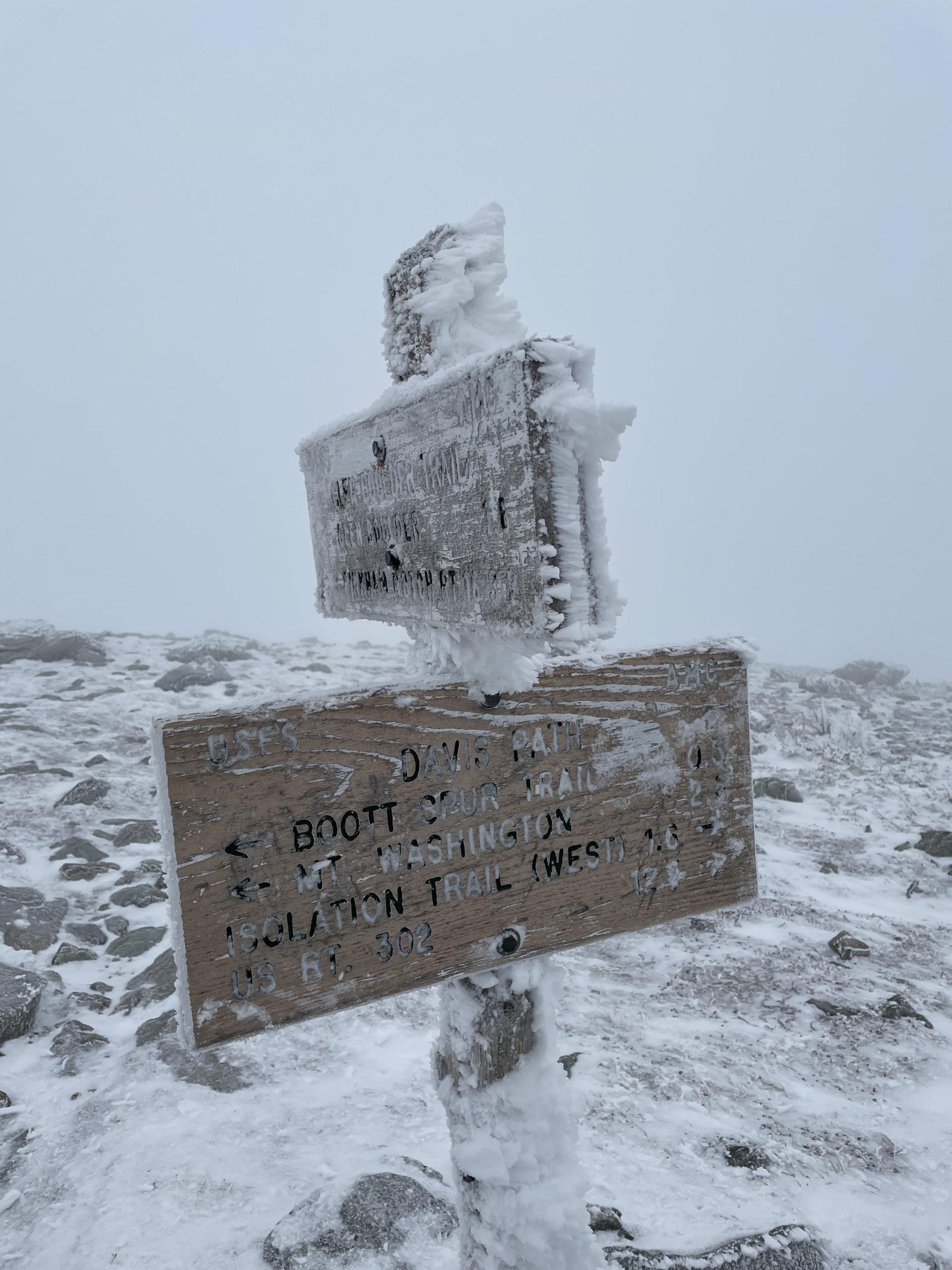
By the time I reached Davis Path, three miles from Rt 16, I’d been hiking for three hours. That’s two times longer than my average pace. The wind was picking up, and as I started south on Davis, I realized I was descending. Mt. Isolation was over three miles away. If I kept descending, that meant I’d have to climb three miles back up after I summitted. I was getting cold. My knee started hurting the moment I took a step downhill. I felt like I was hiking into the abyss, and frankly, I was spooked.


Where the hell was Jon Snow when I needed him?
I turned around. I was pretty darn relieved when I got back to Glen Boulder and could finally see my surroundings. Mentally relieved, that is. Not physically. The descent was brutal. I’d had some dull knee pain on previous hikes, but the ache had turned to agony. There were several times when I was sure my knee was going to give out altogether. The downhill was insanely steep. And slippery. I picked up a stick from the side of the trail and used it to support the majority of my right-side weight. It took me almost three more hours to get down, and I have never been happier to see my car.
On the drive home, I thought about how exposed Mt. Isolation had been. At barely 4000 feet, it was just as exposed as many higher hikes I’d done, and I couldn’t figure out why. The question prompted a deeper dive into the nature of elevation as soon as I got home. I learned that in the White Mountains, the treeline is around 4,400 feet. Factors like high wind, low moisture, and cold temperatures inhibit the growth of anything taller than scrub and other groundcover. Sometimes treelines can be lowered by natural causes, like forest fire, or human activity, like land development. But in all my poking around on the Internet, I couldn’t find a reason why a lower summit would be more exposed than a higher one.
And then I looked closely at my map. It turns out the route I took to Mt. Isolation was significantly higher than the peak itself. At the point where I intercepted Davis Path, I was at nearly 5000 feet. Had I continued to Mt. Isolation, I would have descended 1000 feet to reach the peak, then climbed back up 1000 feet to the Glen Boulder Trail junction. In fact, the total elevation gain of this trail is nearly 2000 feet more than the elevation of Mt. Isolation itself. Oh. My. Word. Thank the Old Gods I turned around.
I am going to have to haul myself back up this trail to tag its summit… but I will be waiting for the snow to melt before I do.
Summit lesson: When winter is coming, you sure as hell better turn around.
Mt. Isolation: Glen Boulder Trail to Davis Pass
| Total elevation: 4,004 ft | Elevation gain: 4,931 ft |
| Mileage: 11.5 miles (incomplete) | Alpine exposure: significant, unsheltered |
| Terrain: woods walk, boulders, scrambling, steep incline | Challenges: wind, cold temps, distance, poor visibility, White Walkers in the scrub |
| View payoff: I’m sure its there! | Dogs: on leash… but I wouldn’t bring mine |
Recap: I attempted this hike in the winter, and it ended with a u-turn. While the elevation of Mt. Isolation is relatively low (2nd to last on the 4000s list), getting there requires a climb to almost 5000 feet (which would put it within the top 10 highest peaks). This is a very challenging, long-ass hike that is best saved for good weather. On the plus side, Glen Boulder is one of the coolest things I’ve seen to date and definitely worth a trip!
1 Comment
Mt. Whiteface | 4020 ft | NH - She Hikes Mountains
April 17, 2021 at 10:54 am[…] last (incomplete) hike up Mount Isolation ended with a treacherously steep, slick descent that involved a lot of sideways sliding and […]